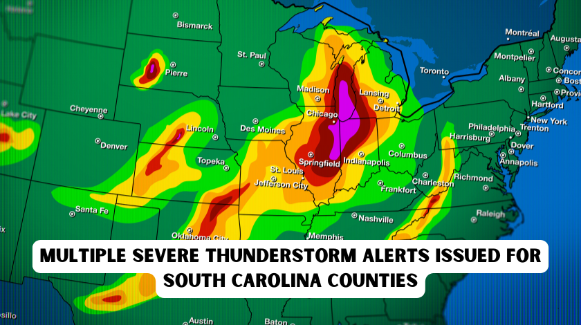
Living in South Carolina means accepting that severe weather is simply part of life here. When those emergency alerts start popping up on your phone one after another, showing multiple severe thunderstorm warnings across different counties, your heart naturally starts racing. I remember sitting on my porch in Columbia last summer, watching the sky turn that eerie greenish-gray color while my phone buzzed constantly with alerts for Richland, Lexington, and Kershaw counties all at once. That feeling of uncertainty, wondering if you should wake the kids, bring in the pets, or head to the basement, is something every South Carolina resident knows all too well.
https://www.example.com/?xPsGxk-3bc1c8
The truth is, severe thunderstorm alerts are becoming more frequent and complex across our state. With South Carolina’s unique position along the Atlantic coast and our mix of coastal plains, rolling Piedmont hills, and mountainous Upstate regions, weather patterns can shift dramatically from one county to the next. When the National Weather Service issues multiple alerts simultaneously, it creates a web of confusion for residents trying to understand which warnings apply to them and what actions they should take.
This comprehensive guide draws from real experiences, official guidance from the South Carolina Emergency Management Division, and practical wisdom from longtime residents who’ve weathered countless storms. Whether you’re new to the state or a lifelong Carolinian looking to refresh your preparedness knowledge, understanding how to respond when multiple severe thunderstorm alerts light up your phone can literally save your life and protect your property.
Understanding Severe Thunderstorm Alerts in South Carolina
The first thing every South Carolina resident needs to understand is the critical difference between a watch and a warning. This distinction seems simple, but in the panic of receiving multiple alerts, even experienced residents can mix them up. A severe thunderstorm watch means conditions are favorable for severe storms to develop. Think of it as the atmosphere loading the gun. These watches typically cover large areas, sometimes multiple states or dozens of counties, and can last for several hours. When you see a watch issued, it’s your cue to start paying attention, charge your devices, and review your emergency plans.
A severe thunderstorm warning, however, means the gun has been fired. These warnings indicate that severe weather is happening right now or will happen within minutes. The National Weather Service issues warnings based on radar detection or trained spotter reports, and they cover much smaller, specific areas, sometimes just portions of counties. When multiple warnings are issued across South Carolina counties simultaneously, it usually indicates a powerful storm system moving across the state, creating a dangerous situation that requires immediate action.
South Carolina’s geography makes these multiple alerts particularly common. Our state stretches from the mountains in the northwest to the Atlantic Ocean in the southeast, creating diverse microclimates. A storm system that starts in the Upstate around Greenville and Spartanburg can track eastward, triggering new warnings for Columbia and the Midlands, then continue toward Charleston and the coast, generating additional alerts for coastal counties. This progression means residents in different regions need to stay alert even if their immediate area is currently calm.
The National Weather Service offices in Greenville-Spartanburg, Columbia, Charleston, and Wilmington (which covers the northeastern corner of our state) coordinate closely when these widespread events occur. They use advanced radar systems, satellite imagery, and ground-based weather stations to track storm development. When they issue multiple alerts, they’re not crying wolf; they’re responding to real atmospheric conditions that pose genuine threats to life and property across broad swaths of South Carolina.
Recent Severe Weather Events and Preparedness Initiatives
South Carolina has experienced significant severe weather activity recently, reminding us all why preparedness matters. In March 2026, Governor Henry McMaster designated March 8-14 as South Carolina Severe Weather and Flood Safety Week, a coordinated effort between the South Carolina Emergency Management Division, the National Weather Service, and the Department of Natural Resources. This annual observance highlights the ongoing threat severe storms pose to our communities and provides structured opportunities for residents to learn and practice safety procedures.
During this preparedness week, officials conducted the statewide tornado drill on Wednesday, March 11, at 9:00 AM, activating emergency alert systems and encouraging schools, businesses, and families to practice their shelter procedures. These drills might seem inconvenient when you’re trying to get work done or when the kids are in virtual meetings, but they serve a crucial purpose. When multiple severe thunderstorm alerts are popping up across counties, and you have minutes to decide whether to take shelter, muscle memory from these drills kicks in and helps you act decisively rather than panicking.
The University of South Carolina’s Carolina Alert system provides a perfect example of how these warnings work in practice. On March 12, 2026, a severe thunderstorm warning was issued for the Columbia campus, triggering immediate notifications to students, faculty, and staff to seek safe shelter. These campus-specific alerts often mirror broader county warnings but provide targeted guidance for people in large institutional settings. When you’re dealing with multiple county alerts, understanding that these localized systems exist helps you filter the noise and focus on actionable information.
Historical context matters too. South Carolina averages 20 to 25 tornadoes annually, but severe thunderstorms without tornadoes cause significant damage every year. The October 2015 floods, while primarily a rain event, started with severe thunderstorm systems that stalled over the state. Hurricane Helene’s impacts in September 2024 included severe thunderstorm warnings across multiple counties as the system moved inland. These events demonstrate that severe thunderstorms aren’t isolated incidents; they’re part of South Carolina’s regular weather pattern, and the multiple alert scenarios we experience are the norm, not the exception.
Essential Safety Steps When Multiple Alerts Are Issued
When your phone starts buzzing with multiple severe thunderstorm warnings for different South Carolina counties, your first instinct might be to check social media or call a friend to see what’s happening. Resist that urge. Your first action should always be to get to a safe location. Social media can wait; your safety cannot.
If you’re at home when multiple alerts are issued, move to a central interior room on the lowest floor of your building. This typically means a bathroom, closet, or hallway away from windows. South Carolina homes vary widely in construction, from historic coastal cottages to modern suburban developments, but the safety principles remain consistent. Put as many walls between yourself and the outside as possible. If you have a basement, use it, though many South Carolina homes, particularly in coastal and low-lying areas, don’t have them due to high water tables.
Avoid windows at all costs. One of the most dangerous misconceptions is that you should open windows to equalize pressure during a storm. This is completely false and dangerous. Modern construction allows buildings to withstand pressure changes, and opening windows actually creates more vulnerability to flying debris and wind damage. Keep windows closed and stay away from them.
If you’re driving when multiple county alerts come through, your situation becomes more complex. Do not attempt to outrun the storm by speeding. Instead, find a sturdy building and seek shelter inside. If no building is available, pull over, keep your seatbelt on, and lower your head below the windows, covering yourself with a blanket or coat if available. Never seek shelter under highway overpasses; the wind tunnel effect can make these areas more dangerous than open ground.
Technology plays a crucial role in staying safe during multi-county alert events. Every South Carolina resident should have multiple ways to receive warnings. Wireless Emergency Alerts on your phone are automatic, but they can be delayed or missed if you’re in a dead zone. NOAA Weather Radios with tone alerts provide reliable backup, especially during power outages. Many South Carolina counties also offer opt-in emergency notification systems that provide more detailed local information than national alerts.
When multiple counties are under warnings, pay attention to the specific areas mentioned in each alert. The National Weather Service includes detailed location information, often listing specific cities, highways, and landmarks. If you’re in Richland County but the warning specifically mentions northeastern Richland near Blythewood, and you’re in southern Columbia, your risk level differs from someone in the warned area. However, storms move, and conditions change rapidly, so maintain heightened awareness even if you’re not in the immediate warning polygon.
Building Your South Carolina Emergency Plan
Having a solid emergency plan transforms the chaos of multiple severe thunderstorm alerts into manageable, actionable steps. Start with communication. When warnings are issued, phone lines often become jammed as everyone tries to check on loved ones. Establish a family communication plan that includes out-of-state contacts who can relay messages between family members if local networks are overwhelmed. Text messages often go through when voice calls fail, so teach children and elderly family members how to send status updates via text.
Your emergency kit should reflect South Carolina’s specific climate challenges. Include at least three days of non-perishable food and water for each family member, accounting for our hot, humid summers when dehydration becomes a real risk even during storm events. Pack flashlights and battery-powered fans, as power outages during thunderstorms can last for days, particularly in rural counties where utility infrastructure is more vulnerable. Keep a whistle in your kit to signal for help if trapped, and include a battery-powered radio to receive updates if cell networks fail.
Home preparation requires seasonal attention. In spring and summer, when severe thunderstorm season peaks, trim trees and remove dead branches that could become projectiles. Secure outdoor furniture, grills, and decorations that high winds could turn into dangerous missiles. If you live in a mobile home, have a predetermined plan to evacuate to a sturdier shelter when warnings are issued. Mobile homes offer virtually no protection against severe thunderstorm winds, regardless of tie-downs or anchors.
Consider the specific needs of vulnerable family members. Elderly relatives or those with mobility challenges need clear, practiced routes to safe areas that avoid stairs if possible. Pets should have carriers ready and be included in your shelter plan; many storm-related injuries occur when people try to retrieve frightened pets at the last minute. If you have infants, keep formula, diapers, and comfort items in your emergency kit.
Know your county’s emergency resources. Each South Carolina county has an emergency management director who coordinates with SCEMD during widespread events. Familiarize yourself with your county’s emergency shelter locations, particularly if you live in flood-prone areas or structures vulnerable to wind damage. When multiple counties are under alerts simultaneously, shelter spaces fill quickly, so having backup options identified in advance is crucial.
After the Storm: Recovery and Resources
Once the warnings expire and the storm passes, the danger isn’t over. Downed power lines, flooding, and structural damage create post-storm hazards that require careful navigation. When multiple counties have been affected, emergency services are stretched thin, meaning you might need to handle immediate safety issues yourself while waiting for professional help.
First, check yourself and family members for injuries. Adrenaline often masks pain during emergencies, so do a systematic check for cuts, bruises, or more serious injuries. If anyone needs medical attention, call 911 immediately, but be prepared for longer response times if the storm affects a broad area. Use your phone only for emergencies to keep lines open for critical calls.
Assess your home’s safety carefully. Look for structural damage, gas leaks (indicated by smell or hissing sounds), and electrical hazards. If you smell gas or see sparks, turn off the main gas valve and circuit breakers if you can do so safely, then evacuate. Do not enter flooded basements or rooms with standing water where electricity might be active. Take photos of damage for insurance purposes before you begin cleanup, as documentation is crucial for claims.
When multiple counties are affected, power restoration can take days. SCEMD coordinates with utility companies to prioritize repairs, focusing first on hospitals, emergency services, and critical infrastructure. Keep your refrigerator closed as much as possible to preserve food, and never use generators, grills, or camp stoves inside your home or garage due to carbon monoxide poisoning risks.
Insurance and recovery resources become critical in the days following widespread storm events. Contact your insurance company promptly to start the claims process. The South Carolina Emergency Management Division assists in its recovery programs, helping individuals and families navigate federal aid applications and local resources. Visit scemd.org for updated information on available assistance after major storm events.
Community support networks activate during multi-county storm events. Neighbors helping neighbors becomes essential when professional services are overwhelmed. Check on elderly neighbors and those with disabilities who might need assistance with cleanup or basic needs. Local churches, community centers, and volunteer organizations often organize relief efforts, providing food, water, and temporary shelter for those with significant damage.
Expert Tips from South Carolina Weather Professionals
Meteorologists who specialize in South Carolina weather emphasize that our state’s severe thunderstorm season runs primarily from March through August, with a secondary peak in November. During these months, atmospheric conditions favor the development of powerful storms that can spawn tornadoes, produce damaging hail, and create flash flooding. When you see multiple alerts issued across counties during these peak periods, take them seriously, even if your immediate area seems calm.
Local experts recommend investing in a NOAA Weather Radio with Specific Area Message Encoding (SAME) technology. These devices can be programmed to alert you only for warnings affecting your specific county or even your neighborhood, filtering out the noise of alerts for distant areas. This targeted alerting helps reduce alert fatigue while ensuring you receive critical warnings immediately.
South Carolina’s weather patterns often involve storm systems that train over the same areas repeatedly, a phenomenon meteorologists call “training.” When multiple counties are under alerts, pay attention to whether the same areas are being warned repeatedly, as this indicates persistent heavy rainfall that dramatically increases flash flood risks. The “turn around, don’t drown” message isn’t just a catchy slogan; it’s lifesaving advice based on the reality that most flood-related deaths occur in vehicles.
Technology continues to improve warning capabilities. The Wireless Emergency Alert system now includes more precise location targeting, and smartphone apps from local news stations and the National Weather Service provide real-time radar and storm tracking. However, experts caution against relying solely on any single technology. Have backup power sources for your devices, and maintain traditional alert methods like weather radios as fail-safes.
Conclusion
Multiple severe thunderstorm alerts across South Carolina counties represent serious weather events that demand respect and preparation. By understanding the difference between watches and warnings, maintaining multiple alert systems, preparing your home and family in advance, and knowing how to respond during and after storms, you transform from a passive recipient of emergency notifications into an active participant in your own safety.
The key is preparation before the alerts arrive. When your phone starts buzzing with warnings for neighboring counties, you’ll have the confidence that comes from knowing you’ve done everything possible to protect yourself and your loved ones. South Carolina’s weather will always be unpredictable, but your response doesn’t have to be.
Frequently Asked Questions (FAQ)
Q1: What’s the difference between a severe thunderstorm watch and a warning? A watch means conditions are favorable for severe storms to develop, covering large areas for several hours. A warning means severe weather is occurring or imminent within minutes, covering specific, smaller areas. When multiple counties have watches, stay alert. When they have warnings, take immediate shelter.
Q2: How do I know which county alerts apply to me? Check the specific locations mentioned in each alert. The National Weather Service lists cities, highways, and landmarks within warning areas. If you’re near the boundary, err on the side of caution and take shelter, as storms can move quickly and warnings are updated frequently.
Q3: Why does South Carolina get so many multiple-county storm alerts? Our state’s geography, stretching from mountains to coast, creates diverse weather patterns. Storm systems often track west to east across the state, triggering sequential warnings as they move through different regions. This progression is normal for our climate.
Q4: What should I do if I’m driving when multiple warnings are issued? Find the nearest sturdy building and seek shelter immediately. Do not try to outrun the storm. If no shelter is available, pull over, keep your seatbelt on, and protect yourself from flying debris. Never stop under highway overpasses.
Q5: How can I receive alerts if my phone dies or has no signal? Invest in a NOAA Weather Radio with battery backup. These devices receive alerts directly from the National Weather Service and work even when cell towers are down. Many South Carolina retailers carry these radios, and they’re essential for areas with spotty cell coverage.
Q6: What makes a thunderstorm “severe” according to the National Weather Service? Severe thunderstorms produce hail one inch or larger in diameter, wind gusts of 58 mph or higher, or tornadoes. These criteria indicate storms capable of causing significant property damage and posing serious risks to life safety.
Q7: Should I open my windows during a severe thunderstorm to equalize pressure? Absolutely not. This is a dangerous myth. Keep windows closed and seek shelter in an interior room away from windows. Opening windows creates vulnerability to flying debris and wind damage while providing no safety benefit.
Q8: How long do I need to stay in the shelter after a warning expires? Wait at least 30 minutes after the warning expires and after you hear the last thunder clap. Lightning can strike miles from the storm center, and conditions can change rapidly. Monitor local news and weather apps for confirmation that the threat has passed.
Q9: What should I include in my South Carolina emergency kit specifically for thunderstorms? Include three days of water and non-perishable food, flashlights, a battery-powered radio, first aid supplies, medications, important documents in waterproof containers, cash, phone chargers with battery packs, and comfort items for children and pets.
Q10: Where can I find official information after multiple counties are affected by storms? Visit scemd.org for South Carolina Emergency Management Division updates, check your local National Weather Service office website (Greenville-Spartanburg, Columbia, or Charleston), and follow official county emergency management social media accounts for localized recovery information.